About Me

Showing posts with label The Lincoln Highway. Show all posts

Friday, October 19, 2012

This Week in Rock Springs Park History

On October 17, 1930, The three governors of Ohio, West Virginia, and Pennsylvania met at the junction of the William Penn Highway (U.S. Route 22) and the Lincoln Highway (U.S. Route 30) in Imperial, PA, for a ribbon cutting ceremony celebrating the completion of both roads during the Depression. This included the recently completed 3-mile stretch through Chester. Read more at http://rockspringspark.blogspot.com/2011/07/governor-of-wv-attends-celebratory.html.


Thursday, August 2, 2012

A Peek at the Lincoln Highway?

On the back cover of Images of America: Rock Springs Park I wrote, “Once described as “a place where god and man went fifty-fifty to produce perfection,” Rock Springs Park was an amusement park located along the Lincoln Highway in Chester, West Virginia.” The Lincoln Highway or Route 30 also ran past Idlewild Park, in Ligonier. Both Idlewild and Rock Springs were once owned by C.C. Macdonald.


The photograph above shows the Ligonier home of C.C. Macdonald. The home still stands today across Route 30 from Idlewild's present exit gate. I was wondering if the white posts, left of the house in this photograph, might be an early guardrail system for the Lincoln Highway prior to its widening along this stretch. The jury is still out, but when one looks at the evidence it seems fairly certain. (Courtesy of Tish Hand)

Takes a look at a close-up view of the posts in question and one can see lines of wire or cable strung between them.

These two postcard views of the LH in Pennsylvania, in the area of Idlewild Park, show the same type of guardrail.

So, what do you guys think? Is it or isn’t it?


Friday, July 6, 2012

The Lincoln Highway Turns 30

Wednesday, July 6, 1927

On this date in Rock Springs Park History, The Lincoln Highway became Route 30. Read more about RSP and the LH at http://rockspringspark.blogspot.com/2011/07/governor-of-wv-attends-celebratory.html.

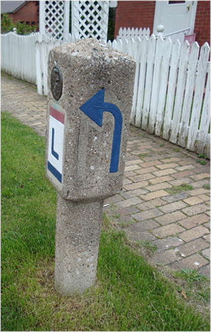
In my youth it was a rite of passage to be tall enough to leapfrog this concrete LH marker with a blue arrow pointing west toward Virginia Avenue. It, along with two others, remain in a three block stretch in my old neighborhood.

Friday, June 15, 2012

Ohio River Bridge Becomes Toll-Free

Friday, June 15, 1951

On this date, the Pittsburgh Post-Gazette reported that the Chester Bridge officially became toll-free.
Ceremonies Held At East Liverpool

East Liverpool, O., June 15 (Special) - The state-owned Ohio River Bridge between here and Chester, W.Va., became toll-free today.

Ohio Atty. Gen. C. William O'Neill and William Ansel Jr., West Virginia state treasurer, spoke at ceremonies marking the end of tolls on the 55-year-old span.

Operated by Commision

The Bridge has been operated by the Ohio Bridge Commission since 1938. An East Liverpool delegation, headed by Chamber of Commerce President Robert Hays, had accused the commission of deliberately holding up freeing the bridge in order to keep the commission in business.

Route 30, the Lincoln Highway crosses the structure. Many Pittsburgh residents use the bridge.

The commission announced it has some $80,000 more than necessary to pay off all obligations on the East Liverpool bridge.


Saturday, April 21, 2012

1940 Census, Part II: The Finley Brothers and C.A. Smith

In the first part of this series of blog posts, I told of Clarence Durbin and Alvin and Hazel Babb who worked at Rock Springs Park and lived in my neighborhood in Chester, according to the recently released 1940 U.S. Census Records. Being a big fan of the park’s history and an author of a book on the subject it was interesting to discover that many influential park workers and performers lived just a few doors down from my old stomping grounds.


Just around the bend on 3rd Street from my house growing up in Chester were The Finleys. The friendly couple lived in one of only two ranch-style homes in the neighborhood made up of mostly two-story clapboards. I passed the Finleys' house daily on my way to school or the family drugstore in town. Their home was bordered on one side by a concrete Lincoln Highway marker and on the other by a house near the old bridge over the railroad tracks which had a small monkey tied to a tree in the backyard in summer. The concrete marker was something to leap frog and the monkey was vastly entertaining to kids in the neighborhood.

The Finleys would often sit on their small front porch and greet me on my way to and from town. What I didn’t realize at the time was Mr. Finley was a member of The Finley Family in town. The Finley Brothers Construction Company built nearly every iconic building in Rock Springs Park, including the octagonal carousel pavilion, and just about every other building in Chester as well. According to Sayre Graham, Jr., whose father worked for the company, they built the Chester High School, the City Hall, and C.A. Smith’s huge cattle barn at Hillcrest (seen above) among others.

The 1940 Census tells us that the Mr. Finley I knew was not one of the original Finley Brothers, but most likely a son or nephew. Listed was Joseph Finley who owned an older home across the alley from where the ranch house would later sit. Today 315 Third Street has a pool in its side yard. In 1940, the house and property are listed at a value of $6,000 and Joseph is identified as being 75-years old and head of the household he shared with his wife Ella and two daughters. His occupation is “contractor – lumber and building” and even at 75, he was not retired with number of hours worked during the week of March 24-30 listed as forty-four.

I am assuming at this time, until confirmed, that the Robert Finley residing at nearby 253 Virginia Avenue, my old street, was another Finley Brother. At age 69 Robert with his wife “Ollie” and son Robert, Jr. age 29. (Could Robert, Jr. be the Mr. Finley I knew?) Robert, Sr. was a carpenter at the lumber company, so I am sure he was a Finley Brother of the construction trade.

If only my interest in the Rock Springs Park had been as great back in the 1970s as it is today, I’m sure all of my Finley neighbors would have had some interesting stories to tell of the park and their buildings which I so admire. I did, however, have the occasion to visit the home of the other subject of this post that of C.A. Smith.

In 1978 I was asked to meet a fellow thespian to run lines for a high school production of the musical “Oliver!” at the old Smith residence. The cast member was playing the Artful Dodger and was a cousin of the William A. Watson Family who owned the big house on the terraced hillside at the time. She was one of two female Artful Dodges to play opposite my part in the show. My interest in the house at that time was not so much the fact that it had once been owned by former Rock Springs Park owner C.A. Smith but that it had an elevator inside. When we finished practicing our parts in the living room of the largest house in town, Jack Dawkins and Oliver Twist, of course, rode the elevator to the second floor. “Consider yourself at home!”
1978 Oak Glen High School Little Theatre Production of "Oliver!" I was too old for the part of Oliver Twist (red vest right).
By the time the census was taken in 1940, C.A. Smith was no longer the lessee or manager of Rock Springs Park. Since 1926, the park had been leased to C.C. Macdonald and by 1935 managed by his daughter Virginia and her husband Bob Hand.

On the census, the 73 year-old Smith is listed as “Corporate Exec” and “Pottery Mag.” (I wonder if “mag” is magnate.) It is interesting to note that Smith is listed at the top of the census chart (see image 1, above), most likely because his was the first home, geographically speaking, along Pyramus Avenue. But it is not too difficult to picture him making it a point with the census taker to be listed above everyone else. He had that kind of influence. His home was valued at $25,000 or 1 million in today's dollars.

The Smith residence is only one of two Chester homes I have come across in the 1940 census so far to have servants. The other, listed directly below C.A. Smith on the document is brother, William Smith, pottery salesman. The C.A. Smith household lists as its permanent residents: C.A., wife Mary E., and servants Ada Mobley and William DeVaugin. Mobley, age 46, was the cook and Devaugin, age 77 Mr. Smith’s butler. Mobley lists her birthplace as Jacksonville, Florida, while Devaugin’s is Camden, New Jersey.

Tuesday, March 20, 2012

Almost Heaven Lincoln Highway

The Almost Heaven Lincoln Highway book I mentioned back on October 7 is now for sale at Blurb Bookstore. The cover of the book uses what appears to be a foggy early morning black and white photograph of the Almost Heaven sign in the front yard of the Rustic Log Home which originally sat at the southern end of the midway in Rock Springs Park. In fact, there is no title font on the book's cover; the sign in the photograph says it all.

A hardcover ImageWrap copy of the book is $75.95 and the softcover is $56.95.

The website describes the book as "an odyssey along the Lincoln Highway with Kass and Eric Mencher as they search for the people and places that shape a complex country in unexpected ways. The Menchers focus on both the mundane and the unordinary, piecing together a nuanced and textured portrait of life along the nation's first cross-country road."

Friday, October 7, 2011

Almost Heaven

The proposed cover of a new book on the Lincoln Highway features the "Almost Heaven" sign displayed in the front lawn of Rock Springs Park’s Rustic Log Cabin after it was moved 100 yards to avoid “the path of progress” in 1974. Don Chaney, who purchased the log house at auction for 100 dollars, had the sign constructed to greet visitors crossing the new Jennings Randolph Bridge from Ohio into West Virginia. The image (above) on the cover of Eric and Kass Mencher's photographic tribute book shows the sign, placed as it is today, against the cement wall of the park’s arched Shoot-the-Chutes Bridge.

For more information on the book and to find out how you can support its completion read Brian Butko’s Lincoln Highway News at http://brianbutko.wordpress.com/2011/10/05/new-lincoln-highway-photo-book-underway/.

Friday, July 8, 2011

A Road by Any Other Name

Improvements along Chester’s main street in the past several years have included brick-lined sidewalks and new lampposts sporting red and blue banners noting places of historical significance; including the old Chester High School, the World’s Largest Teapot, and my favorite – Rock Springs Park (pictured).

Growing up in Chester, West Virginia, I often incorrectly identified the main street through town as “Main Street.” Mostly this was because I lived on a dead end and many lost drivers would interrupt a street wiffle ball game or a game of catch to ask us for directions to the bridge. It was easier to refer to the main drag though town as “Main Street” rather than its given name “Carolina Avenue.”

There have been two Chester Bridges – the old one and the new one. The old one at First Street closed in 1969 and the new one opened in 1977. During the intervening years, drivers used Newell's toll bridge.

Carolina Avenue in Chester is clearly "Main Street" as it is the address for the post office, fire department, several banks, and most other businesses. You enter Chester at one end of Carolina Avenue and exit at the other. Plus, It’s the only street in town with traffic lights – four at present – two when I was a kid . Not to mention, geographically speaking, Carolina Avenue neatly divides Chester right down the middle with the mountains to the south and the Ohio River to the north. Historically speaking, it was the very first road in town.

Our family business, Herche's Pharmacy, was located on Carolina Avenue and Third Street in Chester.

The reason many vehicles stopped and asked for directions in my old neighborhood was because at one time Carolina and Virginia Avenues were along a trolley route that led from East Liverpool, Ohio, across the old Chester Bridge and on to Rock Springs Park. Approaches to bridges in those days were not sprawling clover leaf exchanges like today, but could be found anywhere; including at the end of a winding neighborhood street like ours or at an abrupt 90 degree turn like the one off Route 2 to enter the Newell Bridge. Before the interstates, drivers had to go through the small towns and in many instances the main drag was not a straight shot.

There was no gentle cloverleaf-style off-ramp at the northern portal of the Chester Bridge. Drivers were forced to make a sharp left into downtown East Liverpool.

In Shakespeare's Romeo and Juliet, Juliet delivers the famous line, “What's in a name? That which we call a rose by any other name would smell as sweet,” meaning “What matters is what something is, not what it is called.” This is apropos when talking about Carolina Avenue in Chester. A quick Google Map search shows it to be Route 2 today. Before the new Chester Bridge (which by the way is actually called “The Jennings Randolph Bridge”) was built, the old trolley route through town was designated as part of the three mile section of the Lincoln Highway through West Virginia, making Carolina Avenue also the Lincoln, and then Route 30.

Call it "Route 2", "Route 30", "The Lincoln", or any other name you want, but Carolina Avenue in Chester is still Main Street to me. If you happen to be in town over the 4th of July, as I was last week, and see it festooned in red, white, and blue bunting and rows and rows of American flags, you just might call it "Main Street USA."

Although he did not stop and ask for directions, Jack Nicklaus got lost in my neighborhood looking for the old Chester Bridge in the early 80s. He was heading to Ohio with his father for a tournament, we learned on the evening news. We weren’t sure if it was Jack until he did a three-point turn at the end of our dead end street and we saw his vanity plate which read, “PGA.”

Saturday, July 2, 2011

Governor of WV Attends Celebratory Lunch at Park

On October 17, 1930, the three governors of Ohio, West Virginia, and Pennsylvania met at the junction of the William Penn Highway (U.S. Route 22) and the Lincoln Highway (U.S. Route 30) in Imperial, PA, for a ribbon cutting ceremony celebrating the completion of both roads during the Depression. This included the recently completed 3-mile stretch through Chester.

"The gathering of more than 5,000 persons," reported the Pittsburgh Post Gazette on October 18, 1930, “came in automobile caravans from Ohio and West Virginia, met the Pennsylvanians there and weathered the discomfort of a chilling drizzle."

Heading north in Chester the Lincoln Highway turns west at the intersection of Taylor Road and Carolina Avenue (Photograph by Clarence O. Durbin taken atop the Cyclone Roller Coaster; Courtesy of Rich Brooks)

Prior to the ribbon cutting, each governor gave a speech in his home state and then traveled by motorcade to Imperial for the afternoon dedication. Governor Myers Y. Cooper, of Columbus, held a noon meeting in Steubenville, Governor John S. Fisher, of Harrisburg, was entertained at a luncheon in Pittsburgh, Governor William G. Conley, of Charleston, W.Va., was the speaker at a ceremony celebrating the completion of the Lincoln Highway between East Liverpool and Pittsburgh, which was to have been held outdoors at Rock Springs Park, but was moved to City Hall most likely due to the poor weather which dampened overcoats but not spirits that day.

"This event," Governor Fisher declared, "is remarkable as a tri-state celebration forming a closer and more intimate union between three states already closely linked through many respects."

According to an article in the Pittsburgh Post Gazette, dated October 18, 1930, “Governor Conley and his party were guests at a luncheon at Rock Springs Park, Chester, where the exercises where originally scheduled to be held.”

It is believed that the Governor and his guests dined at the Green Lantern Restaurant constructed in 1927 by then park owner C.C. Macdonald near the lower trolley loop entrance to Rock Springs Park. Arrangements for the Chester celebration were made by a committee representing the East Liverpool chamber of commerce, the Chester board of trade, and Hookstown, Georgetown and Lisbon.

One of the original owners of Rock Springs Park, C.A. Smith (center), was said to have used his political influence to lobby for West Virginia alignment of the Lincoln Highway. (See Images of America: Rock Springs Park p. 65.)

The Lincoln Highway was officially marked and dedicated on September 1, 1928. On that day, at 1:00 p.m., groups of Boy Scouts placed 3,000 concrete markers at sites along the route. They were placed on the outer edge of the right-of-way at each important crossroad and at minor crossings, to assure each motorist that he was on the right road. The signs carried the Lincoln Highway insignia, a bronze medallion, and a directional arrow.

In my youth it was a rite of passage to be tall enough to leapfrog this concrete LH marker with a blue arrow pointing west toward Virginia Avenue. It along with two others remain in a three block stretch in my old neighborhood.